Insider tip: Norway's first inofficial scenic route
"Nasjonale Turistveger" is the initiative of the Norwegian Public Roads Administration to define, develop and present official Norwegian Scenic Routes. So far the website of Nasjonale Turistveger shows a catalogue of 18 worth visiting Norwegian Scenic Routes throughout the whole country.
Of course Norway has a lot more beautiful places and scenic routes. Besides the officially announced routes visitors will find a scenic route in the countryside of Norway's southern county Telemark. The beauty of the landscape and the attractions along the way are worth announcing it as an "inofficial Norwegian Scenic Route".
The Scenic Route Skien - Rjukan
Route description
The scenic route Skien - Rjukan passes through Telemark from county capital Skien first to Notodden and from there in two alternative ways to Rjukan. Along the route the visitor will enjoy a beautiful landscape with forests, long lakes, some quite rivers and wilder flows, a snowcapped mountain, a fell with wide view and finally a waterfall. And moreover, a few attractions can be explored such as Telemark Canal, Heddal stave church, tramways to mountain tops and the UNESCO world heritage site at Rjukan and Notodden.
Route map and data
Link to this map (opens Google Maps)
Start point: Skien, county Telemark (GPS 59.191573, 9.589106)
End point: Rjukan, county Telemark (GPS 59.874364, 8.495584)
Route distance
- along dale (street 361 and 37 / Gransherad): appr. 178 km
- across plateau / fell (street 651 / Tuddal): appr. 177 km
Note: The route across the fell (street 651) is maybe closed in the winter and / or under certain weather conditions.
Tip 1: Best photo light (sun position) across fell is before noon.
Tip 2: By combining both ways you can create a round trip. Also on the southern part of the route you can drive back on opposite lakesides. Or you just take the same street back which will look differently from another perspective.
Travelling to the route
From the Norwegian ferry ports below the starting point Skien is only 30 to 50 kilometers away. Coming from or through Germany you can choose between two travel routes:
- via Hirtshals, Denmark (follow A7, E45, E39) with a ferry to Langesund or Larvik
- via (Denmark &) Malmö, Sweden (follow A1, E47, E20, E6) via Oslo or with a ferry from Strömstad to Sandefjord
See also more details on "travelling to Norway by car" (in German).
See also details and tips about "driving in Norway" (in German).
Attractions of scenic route Skien - Rjukan
Telemark Canal
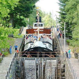
The 105 km long Telemark Canal connects Dalen to Skien and the North Sea by linking several long lakes through a series of 18 locks.
Heddal Stave Church
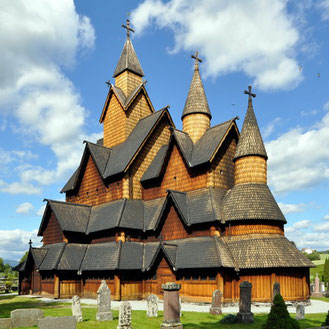
Wooden Heddal stave church was built in the 13th century. With a height of 26 metres it is Norway's largest stave church.
UNESCO World Heritage
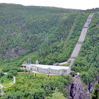
In 2015 the UNESCO inscribed the Rjukan-Notodden Industrial Heritage Site into the world heritage list.
Rjukanfossen
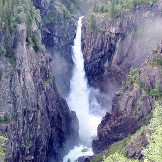
Rjukanfossen is a waterfall with a height of 104 metres. Most of its water is used for energy production.
Gaustatoppen
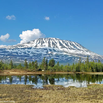
With a height of 1883 metres above sea level Gaustatoppen is the highest mountain in the county Telemark.
Krossobanen
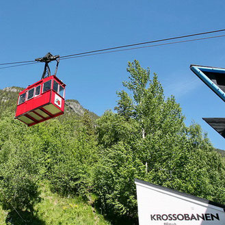
Krossobanen is an aerial tramway. Within five minutes it brings guests up to the top station Gvepseborg on 886 metres.
Further tips for route
- Telemark Canal can also be explored by boat (tourist information).
- Gaustabanen (Google Maps) is an underground tramway to the top of Gaustatoppen mountain offering a very scenic round view.
- Take a break and short walk in Notodden to Kåfjelltoppen (Google Maps) and enjoy the view from this 230 metres high hill.
- Friends of history may enjoy the industrial heritage of Rjukan-Notodden and the story about Norwegian heavy water sabotage in the second world war.
- Friends of music may be also interested in the annual blues festival in Notodden (http://www.bluesfest.no/en/).
Sports possibilities along route
Sport enthusiasts will find a variety of opportunities along the scenic route Skien - Rjukan:
- Canoeing on Telemark Canal or on one of the numerous lakes
- Biking tours in various ways (tourist information), e.g. off-road cycling on the Hardangervidda (e.g. with Krossobanen)
- Hiking in the woods, along lakes or on the fell plateau around Gaustatoppen between Sauland and Rjukan (examples)
- Skiing in Gaustablikk (Touristen-Info)
- Angling at lakes and rivers (take care of getting a license)
- Playing golf:
-
- Close to Skien: http://grenlandgolf.no/
- Close to Ulefoss: http://www.golfparken.no/
- Close to Rjukan: http://rjukangolf.no/
- Extreme sports: Norseman Xtreme-Triathlon
- Women only: The Norwegian hiking day (Norwegian website)
Onward journey after reaching route's end
After arriving in Rjukan there are several alternatives for onward journey or driving back:
- Norway's capital Oslo is worth a trip and a stay. It is only 180 km away and opens the opportunities to continue to middle and north of Norway. From here you can also drive back through Sweden.
- Continue exploring Norway and drive to Fjordland with a lot of attractions and scenic routes (some details and another map about Fjordland in German)
-
- Waterfall Låtefossen (map, web) is the southern entry point to beautiful Hardangerfjord and to official Scenic Route Hardanger
- An alternative way into Hardangerfjord area is via Geilo, Haugastøl and official Scenic Route Hardangervidda
- Another option into middle and northern Fjordland is to drive via Geilo to Flåm (map)
and official Scenic
Route Aurlandsfjellet
- Getting back to Norway's south coast:
-
- Add a fjord experience on a scenic round-trip through South Norway: Drive 150 km to Håra, partly a wonderful fell route. From here you can enter an official Scenic Route Ryfylke with the famous Lysefjord. From route's southern end Oanes you can drive on to ferry ports Stavanger or Kristiansand (both offer ferries back to Hirtshals, Denmark).
- A different and more direct way to Kristiansand is via Dalen and street Rv9.
Links
- Google Map with scenic route, highlights and ferry ports: https://www.google.com/maps/d/edit?mid=1Y7TmcQL7fYwPYB_tIaowivi7dbI&ll=59.469990134712205%2C9.356643399999939&z=9
- Links for daily information update in Norway (weather, traffic, local): https://www.mark-koenig.de/2017/07/03/daily-use-links-for-tourists-in-norway/
- Tips for driving to Norway (German): https://www.mark-koenig.de/reisen/norwegen/anreise-auto-mit-ohne-faehren-routen-daenemark-schweden-tipps/
- Tips for driving in Norway (German): https://www.mark-koenig.de/reisen/norwegen/auto-fahren-erfahrungen-beispiele-tipps/
- Scenic routes, attractions and tips for the touristic region South Norway (German):
- Scenic routes, attractions and tips for the touristic region Fjordland (German):
- Official Norwegian Scenic Routes: http://www.nasjonaleturistveger.no/en
- Norwegian tourist information about "Getting around by car": https://www.visitnorway.com/plan-your-trip/getting-around/by-car/?lang=uk
- Tourist information websites:
-
- Norway: https://www.visitnorway.com/
- Telemark: http://www.visittelemark.com/
- Rjukan: http://visitrjukan.com/en
(c) Author: Mark König
Also pictures from the following photographers were used:
Heddal Stabkirche by Micha L. Rieser
Krossobanen by Trond Strandsberg
Rjukanfossen by Gustavsen
Telemarkkanal by Paasland
Vemork Power Station by Michael Spiller


Write a comment
Jen Sharp (Sunday, 12 July 2020 19:28)
Just want to say this is a really informative post! While we aren't necessarily doing the same route, this was super helpful for our holiday planning! Thanks so much for your effort.